ST_Intersection
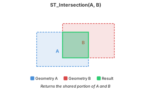
Introduction: Return the intersection of A and B. Geometry inputs use planar overlay; Geography inputs use closed-set spherical overlay with geodesic edges.
Format:
ST_Intersection(A: Geometry, B: Geometry)
ST_Intersection(A: Geography, B: Geography)
Return type: Geometry or Geography, matching the input type
Since: v1.5.0 (Geometry), v1.9.1 (Geography)
Note
This note applies only to Geometry inputs. If you encounter a TopologyException with the message "found non-noded intersection", try enabling the OverlayNG algorithm by adding the following JVM flag:
-Djts.overlay=ng
The OverlayNG algorithm is more robust than the legacy overlay implementation in JTS and handles many edge cases that would otherwise cause errors.
Geometry example:
SELECT ST_Intersection(
    ST_GeomFromWKT("POLYGON((1 1, 8 1, 8 8, 1 8, 1 1))"),
    ST_GeomFromWKT("POLYGON((2 2, 9 2, 9 9, 2 9, 2 2))")
    )
Output:
POLYGON ((2 8, 8 8, 8 2, 2 2, 2 8))
For Geography inputs, boundary-only intersections are retained: crossing lines or touching polygon vertices can produce a Point, while shared polygon edges can produce a LineString. Polygon shells are normalized to an area of at most one hemisphere; a shell intended to represent more than half the sphere is interpreted as its complement. Results containing several dimensions are returned as a GeometryCollection.
The Geography result is two-dimensional and copies the first input's SRID without transforming either input or validating that their SRIDs match. An explicitly empty operand produces GEOMETRYCOLLECTION EMPTY. A disjoint result from two non-empty inputs preserves the lower input dimension.
Geography example:
SELECT ST_AsText(ST_Intersection(
    ST_GeogFromWKT('LINESTRING (0 -5, 0 5)', 4326),
    ST_GeogFromWKT('LINESTRING (-5 0, 5 0)', 4326)
));
Output:
POINT (0 0)