One More Dimension: Apache Sedona Enters the 3D World
In a flat spatial query the world is only its noon shadow on the ground. Two objects whose shadows touch can be four hundred feet apart, and from a flat predicate the answer is the same for both.
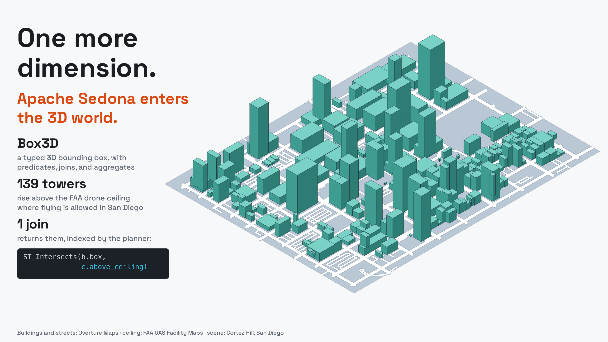
The questions put to spatial engines have stopped being flat. Drones under FAA ceilings, aircraft over towers, apartments above restaurants, mineral deposits below mining leases: each one comes down to whether two volumes meet, and until now the SQL answer was the shadow version. Sedona 1.9.1 adds the missing axis. There is a Box3D type with constructors and accessors, 3D predicates and distances, a 3D extent aggregate, and query plans that account for the third axis.
A box with a z
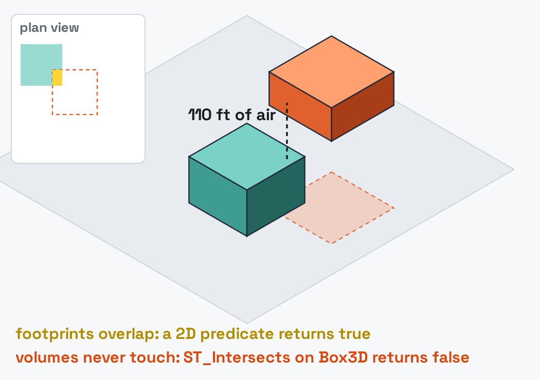
Box3D is six doubles: xmin, ymin, zmin, xmax, ymax, zmax. Build one from any geometry with ST_Box3D, or from two corner points with ST_3DMakeBox; read it back with ST_XMin through ST_ZMax. The z changes answers:
SELECT ST_Intersects(ST_3DMakeBox(ST_PointZ(0, 0, 0),  ST_PointZ(10, 10, 10)),
                     ST_3DMakeBox(ST_PointZ(5, 5, 20), ST_PointZ(15, 15, 25))) AS xy_overlap_z_apart,
       ST_3DDWithin(ST_PointZ(0, 0, 0), ST_PointZ(3, 4, 12), 13.0) AS within_13
+------------------+---------+
|xy_overlap_z_apart|within_13|
+------------------+---------+
|             false|     true|
+------------------+---------+
The two boxes overlap in x and y, which is enough for a true result from a 2D predicate; in the third coordinate the gap between them is ten units. And the 3-4-12 point sits at Euclidean distance 13, the inclusive bound, mirroring PostGIS.
A city becomes boxes
Overture Maps publishes building footprints with a height attribute as GeoParquet on S3, open to anonymous reads. One filter pulls a city out of the planet, and one expression gives every building a volume:
df = sedona.read.format("geoparquet").load(
    "s3a://overturemaps-us-west-2/release/2026-08-19.0/theme=buildings/type=building/"
)
df.where(
    "bbox.xmin BETWEEN -117.30 AND -117.05 AND bbox.ymin BETWEEN 32.60 AND 32.80"
).createOrReplaceTempView("b_raw")
SELECT id, names.primary AS name, geometry, height * 3.28084 AS height_ft,
       ST_3DMakeBox(ST_PointZ(ST_XMin(geometry), ST_YMin(geometry), 0.0),
                    ST_PointZ(ST_XMax(geometry), ST_YMax(geometry), height * 3.28084)) AS box
FROM b_raw WHERE height IS NOT NULL
With row-group pruning against the bounding-box filter, the read covers a San Diego-sized slice of a planetary dataset: 208,477 buildings, 178,384 of them with a height. The tallest is Symphony Towers at 499 ft, a height the third dimension already constrains: downtown sits under the approach path to San Diego International, and the FAA caps its towers.
Session setup: released artifacts, anonymous S3
from sedona.spark import SedonaContext

config = (
    SedonaContext.builder()
    .master("local[*]")
    .config("spark.driver.memory", "8g")
    .config(
        "spark.jars.packages",
        "org.apache.sedona:sedona-spark-shaded-3.5_2.12:1.9.1,"
        "org.datasyslab:geotools-wrapper:1.9.1-33.5,"
        "org.apache.hadoop:hadoop-aws:3.3.4",
    )
    .config(
        "spark.hadoop.fs.s3a.aws.credentials.provider",
        "org.apache.hadoop.fs.s3a.AnonymousAWSCredentialsProvider",
    )
    .config(
        "spark.hadoop.fs.s3a.bucket.overturemaps-us-west-2.endpoint.region", "us-west-2"
    )
    .getOrCreate()
)
sedona = SedonaContext.create(config)
The sky has a ceiling
Drone delivery went from pilot program to arms race this summer: DoorDash earned its FAA air-carrier certificate in July, Uber partnered with Zipline to put drones behind the Uber Eats button, and Amazon and Walmart are already flying. Every one of those aircraft operates inside a volume the FAA has already mapped: the UAS Facility Maps divide the airspace near airports into grid cells, each with a maximum drone altitude from 0 to 400 ft.
San Diego's grid makes the point vividly. Of the 585 cells covering the city, 233 have a ceiling of 0 ft. The approach path is a no-fly corridor drawn straight across downtown. Each cell becomes the box of sky above its ceiling, the volume a compliant drone never enters:
SELECT cell_id, ceiling_ft,
       ST_3DMakeBox(ST_PointZ(ST_XMin(geom), ST_YMin(geom), ceiling_ft),
                    ST_PointZ(ST_XMax(geom), ST_YMax(geom), 2000.0)) AS above_ceiling
FROM cells_raw
Do the volumes meet?
The answer is in neither dataset alone. One join is enough: which buildings rise above the drone ceiling over their own roof?
SELECT COUNT(DISTINCT b.id) AS total_above,
       COUNT(DISTINCT CASE WHEN c.ceiling_ft > 0 THEN b.id END) AS above_in_flyable_cells
FROM bldg b JOIN cells c ON ST_Intersects(b.box, c.above_ceiling)
+-----------+----------------------+
|total_above|above_in_flyable_cells|
+-----------+----------------------+
|      31425|                   139|
+-----------+----------------------+
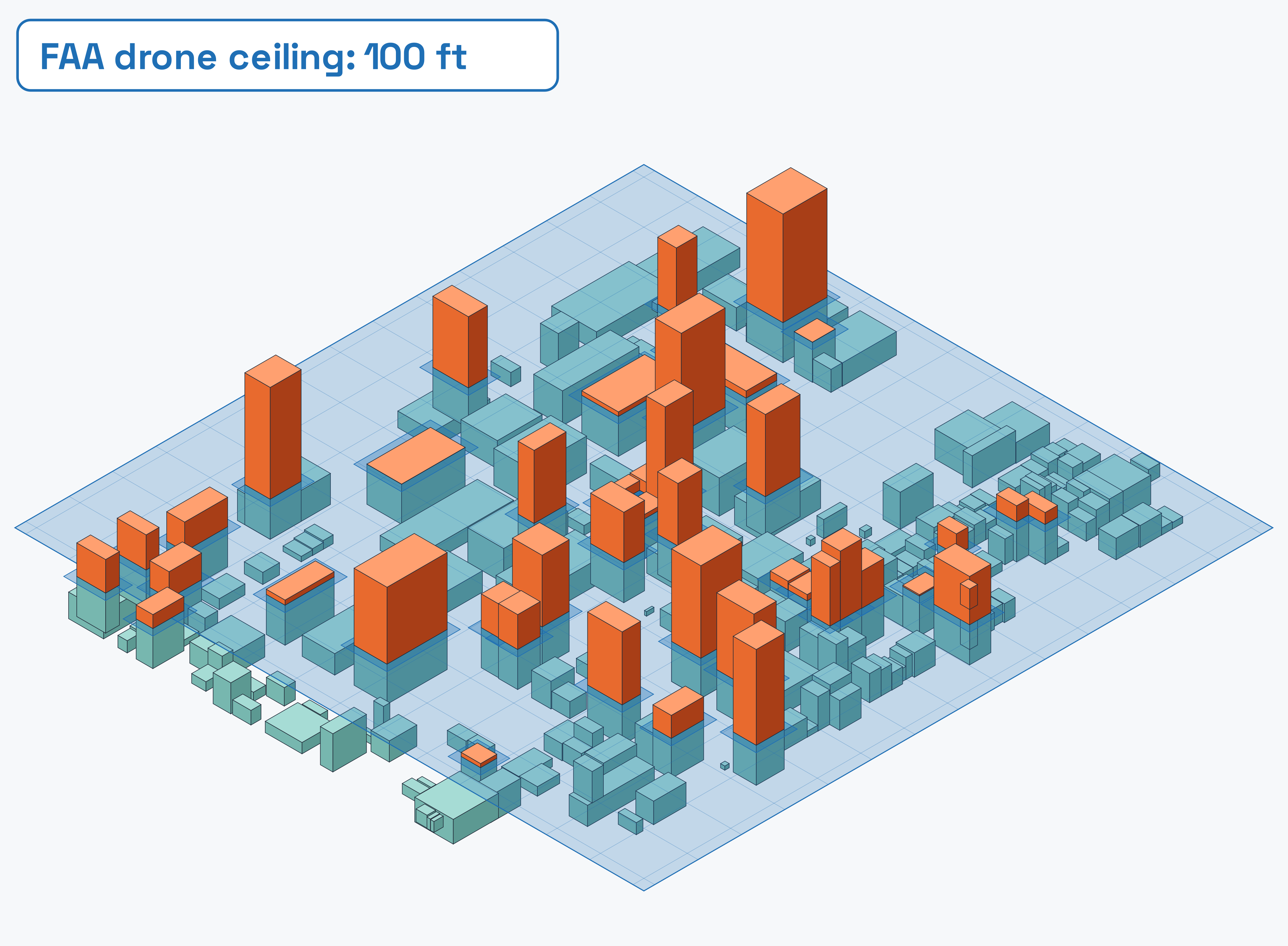
Two numbers, one story. 31,425 buildings stand taller than the ceiling above them, and nearly all sit in the 0 ft cells: the FAA drew its no-fly zones where the city is tall. In the cells where drones may fly at all, only 139 buildings rise into or above the permitted band. Those 139 are the ones a route planner has to know by name; the biggest names on the other list, led by Symphony Towers at 499 ft under a 0 ft ceiling, are the reason the zeroes exist.
Here is the geometry behind that join, in one neighborhood. Around Cortez Hill the ceiling is 100 ft, drawn below as a translucent plane over the real building boxes; every orange volume is a row the join returns:
The join itself runs through Sedona's spatial join machinery. The physical plan shows it:
+- RangeJoin box: box3d, above_ceiling: box3d, INTERSECTS
Box3D predicates and ST_3DDWithin distance joins are indexed by the planner the same way 2D joins are, so the pattern holds when a city becomes a country: boxes are rows, and rows fan out across a cluster.
A corridor through it
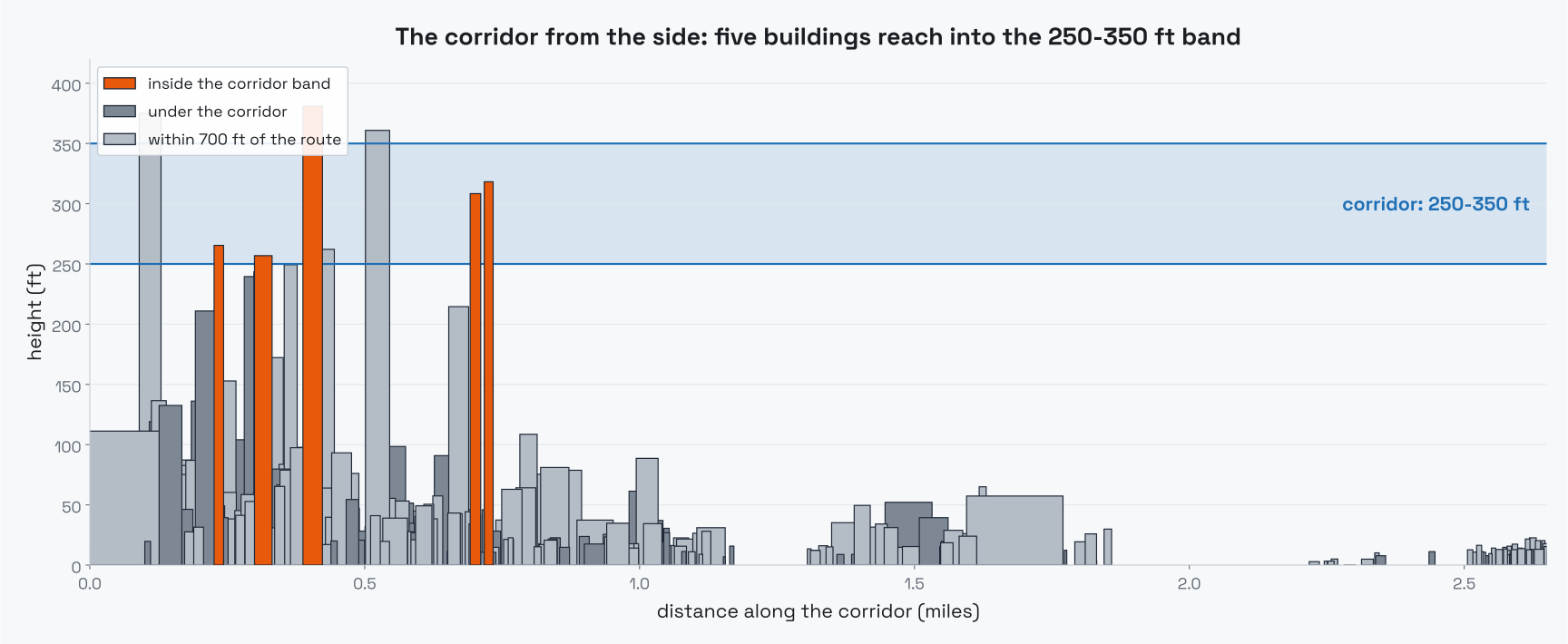
Route planning is the same join from the other side. Take a hypothetical delivery corridor from the convention center toward Hillcrest, three miles at 250 to 350 ft, built as forty stacked boxes:
WITH seg AS (SELECT explode(sequence(0, 39)) AS i),
corridor AS (
    SELECT i, ST_3DMakeBox(
        ST_PointZ(-117.161 + i * 0.0008 - 0.0006, 32.706 + i * 0.001 - 0.0006, 250.0),
        ST_PointZ(-117.161 + i * 0.0008 + 0.0006, 32.706 + i * 0.001 + 0.0006, 350.0)) AS cbox
    FROM seg)
SELECT COUNT(DISTINCT b.id) AS obstructions, MAX(ROUND(b.height_ft, 0)) AS tallest_ft
FROM corridor c JOIN bldg b ON ST_Intersects(b.box, c.cbox)
+------------+----------+
|obstructions|tallest_ft|
+------------+----------+
|           5|     381.0|
+------------+----------+
Five buildings stand inside the corridor's altitude band, the tallest at 381 ft. Swap ST_Intersects for ST_3DDWithin(b.box, c.cbox, 50.0) and the test becomes a 50 ft clearance margin instead of bare contact.
One dimension, many doors
The same six doubles apply well beyond airspace.
Aircraft separation. Aviation's loss-of-separation rule is a volume: a horizontal radius measured on the curved Earth and a vertical band. The horizontal half belongs to 1.9.1's other new type, Geography, which measures geodesic meters; the vertical half is arithmetic:
SELECT ST_DWithin(a.pos, b.pos, 9260.0) AS within_5nm,
       ABS(a.alt_ft - b.alt_ft) < 1000 AS within_1000ft,
       ST_DWithin(a.pos, b.pos, 9260.0) AND ABS(a.alt_ft - b.alt_ft) < 1000 AS conflict
FROM a, b
Two aircraft three miles apart at 12,000 and 12,800 ft come back conflict = true.
Below zero. The axis points down as well. A planned excavation is a box with a negative floor, and a buried utility main is a box at depth:
WITH dig AS (SELECT ST_3DMakeBox(ST_PointZ(0, 0, -12), ST_PointZ(30, 8, 0)) AS site),
pipe AS (SELECT ST_3DMakeBox(ST_PointZ(-100, 3, -9), ST_PointZ(200, 4, -8)) AS main)
SELECT ST_Intersects(dig.site, pipe.main) AS strikes_the_main FROM dig, pipe
It returns true: call before you dig, as a query.
The volume of anything. ST_3DExtent aggregates a column of geometries into its bounding volume. Downtown San Diego's rooftop points collapse to BOX3D(-117.174 32.705 0.1, -117.150 32.725 498.7): the whole skyline in one value, ceiling included.
Seeing it in 3D
For an interactive view, SedonaPyDeck, Sedona's deck.gl integration, extrudes the same table with building height as the elevation column:
from sedona.spark.maps.SedonaPyDeck import SedonaPyDeck

SedonaPyDeck.create_geometry_map(
    df,
    elevation_col="height_ft",
    fill_color="status == 'above the ceiling' ? [255, 90, 60, 235] : "
    "(status == 'no-fly zone' ? [125, 135, 150, 210] : [70, 170, 160, 210])",
)
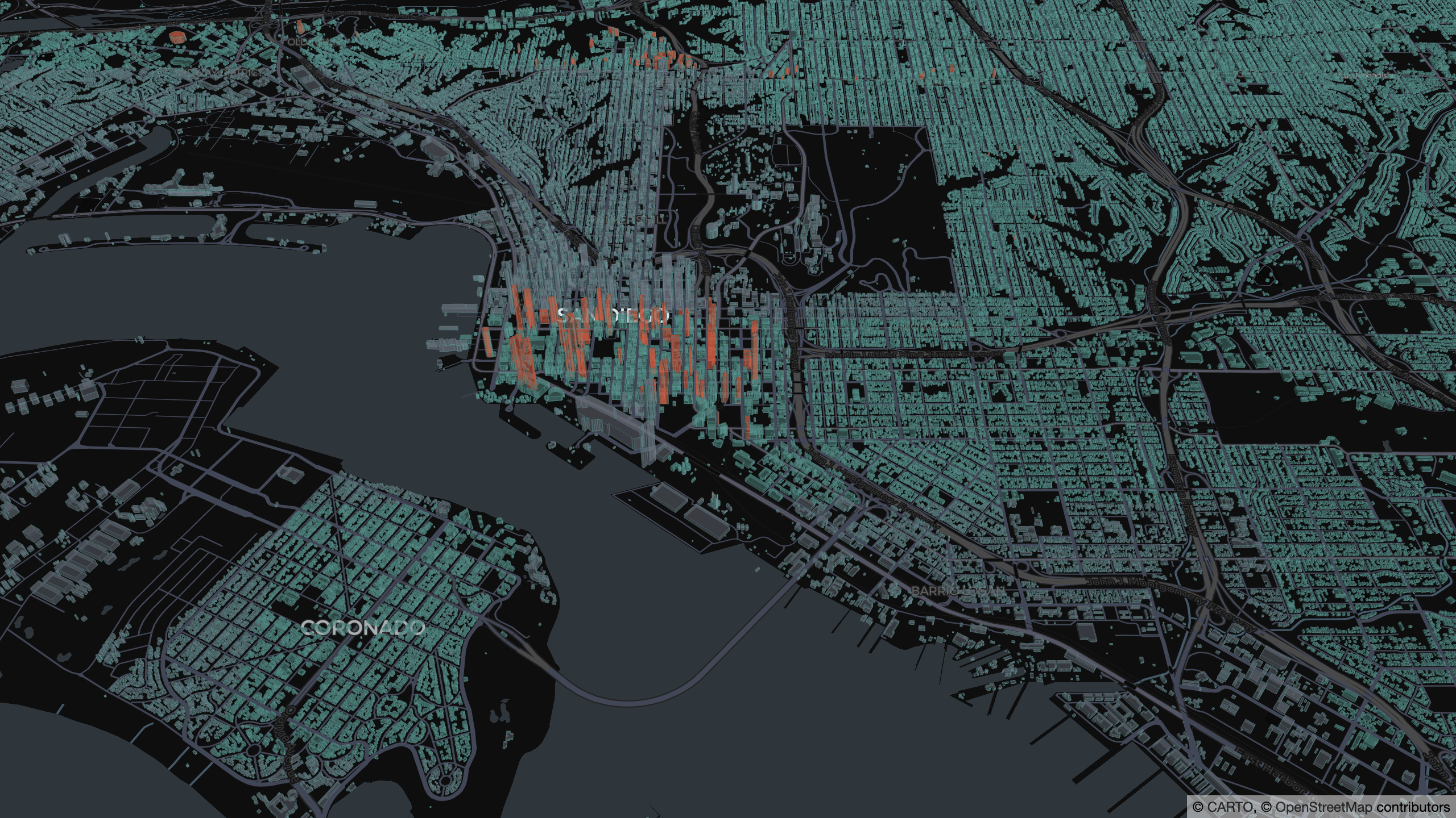
The grey field is the FAA's no-fly grid, visible as geography.
The flat sibling, and the bindings
Box3D arrived alongside Box2D, its planar counterpart, which comes with ST_Extent, box predicates with join support, and GeoParquet row-group pushdown for ST_BoxIntersects filters. Python code receives both as first-class types through the new UDT bindings, and SedonaFlink ships the same constructors, accessors, and predicates for streams.
The point
Flat answers were an artifact of flat tools. The world your data describes has ceilings, floors, altitudes, and depths, and as of 1.9.1 a Sedona query can express all of them: build the volumes in one expression, join them with a planner that indexes the third axis, and draw the result in 3D without leaving the ecosystem.
References: Box3D constructors, ST_3DDWithin, ST_3DExtent, and the 1.9.1 release notes.
Star Apache Sedona on GitHub
A star takes two seconds and helps others discover the projects.